Stratigraphy / Sedimentology
 The study of rock layers is called "stratigraphy." When you study
layers of rock you're not
only studying periods of time, but also environments and how they have
changed. The material that comprises the cliffs is 8 to 17
million years old and consists of thick deposits
of clay and sand that have not
yet been hardened into rock (lithified). Geologists have
grouped these layers into formations. Each formation records
conditions in an environment on the ancient shoreline, such as a beach
or lagoon. Changes from one formation to another records changes
in the environment in which the sediment accumulated.
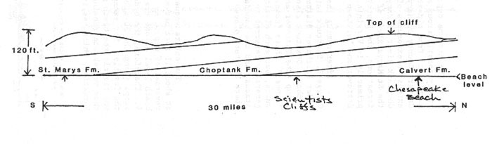
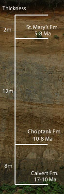
There are three formations exposed in the cliffs of
Calvert County: the St. Mary's, the Choptank, and
the Calvert. A diagram identifiying the formations, their
representative thickness, and relative age at a shoreline location
called "Scientists Cliffs" can be
seen on the right. The sand and clay deposited in this
location offer
geologists a window into the past, and indicate that a near shore
sedimentary environment once existed where dry
land is exposed today. Along the east coast of Calvert County
these formations dip to the southeast at about 11
feet/mile, with the older formations dipping below sea level to the
south. This means that as
one travels south along the western shore of Calvert County (down Bay),
the beds become progressively younger in age (see figure below).
The study of rock layers is called "stratigraphy." When you study
layers of rock you're not
only studying periods of time, but also environments and how they have
changed. The material that comprises the cliffs is 8 to 17
million years old and consists of thick deposits
of clay and sand that have not
yet been hardened into rock (lithified). Geologists have
grouped these layers into formations. Each formation records
conditions in an environment on the ancient shoreline, such as a beach
or lagoon. Changes from one formation to another records changes
in the environment in which the sediment accumulated.
There are three formations exposed in the cliffs of
Calvert County: the St. Mary's, the Choptank, and
the Calvert. A diagram identifiying the formations, their
representative thickness, and relative age at a shoreline location
called "Scientists Cliffs" can be
seen on the right. The sand and clay deposited in this
location offer
geologists a window into the past, and indicate that a near shore
sedimentary environment once existed where dry
land is exposed today. Along the east coast of Calvert County
these formations dip to the southeast at about 11
feet/mile, with the older formations dipping below sea level to the
south. This means that as
one travels south along the western shore of Calvert County (down Bay),
the beds become progressively younger in age (see figure below).
(Drawing courtesy of Rasmussen,
1999)